Tanager-1: Two Years of Turning Satellite Data Into Methane Action
Published on: Aug 17, 2026
Happy TAN-iversary!
Two years ago today, Tanager-1 launched into orbit — transforming how the world sees, verifies, and acts on methane emissions.
Purpose-built to detect methane super-emitters from space, through a groundbreaking partnership between Carbon Mapper, Planet and NASA’s Jet Propulsion Laboratory (JPL), Tanager has exceeded expectations, empowering decision makers around the world to identify and pinpoint the biggest emission sources for fast, effective action.
Since our first methane detection in September 2024, Carbon Mapper has turned Tanager observations into action: advancing methane detection science, publishing public data on thousands of point sources, and working with partners around the world to build capacity, inform policy, and put data directly into the hands of decision makers who can cut emissions at their own operations — from oil and gas facilities to landfills.
We’re making real progress toward our mission to drive greenhouse gas reductions by making methane and CO2 data accessible and actionable. Here’s a look at what we’ve accomplished so far.
What We've Seen
Two Years of Data at a Glance
- Number of published methane plumes: 14.4k
- Number of published CO2 plumes: 3.9k
- Number of published Tanager methane plumes from each sector:
- Oil and gas: 6.5k
- Solid waste: 4.4k
- Coal mining: 3.1k
- Other: 210
- Electricity generation: 91
- Livestock: 60
- Number of published Tanager CO2 plumes from each sector:
- Electricity Generation: 3.0k
- Manufacturing Industries: 686
- Oil and Gas: 132
- Other: 57
Statistics reflect a timeframe of September 19, 2024 (first methane detection) through August 16, 2026
Snapshot: The largest plumes observed by Tanager-1 by volume per sector
Methane
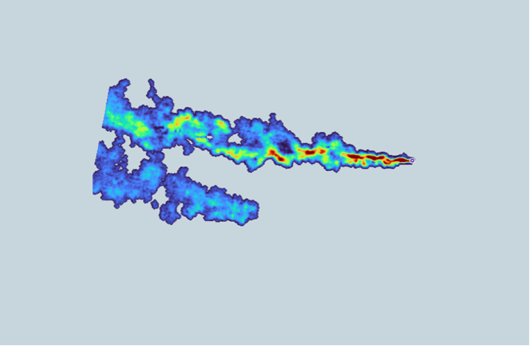
Offshore oil and gas: This plume was detected by Tanager-1 on July 6, 2026, off the coast of Mexico. Carbon Mapper quantified the emissions rate as 25.8k kg CH4/hr.
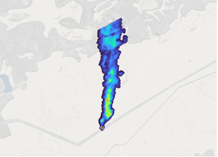
Onshore oil and gas: This plume was detected by Tanager-1 on April 28, 2026, in Russia. Carbon Mapper quantified the emissions rate as 14.1k kg CH4/hr.
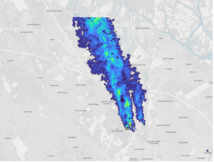
Waste: This plume was detected by Tanager-1 on July 1, 2026, in Argentina. Carbon Mapper quantified the emissions rate as 1.4k kg CH4/hr.
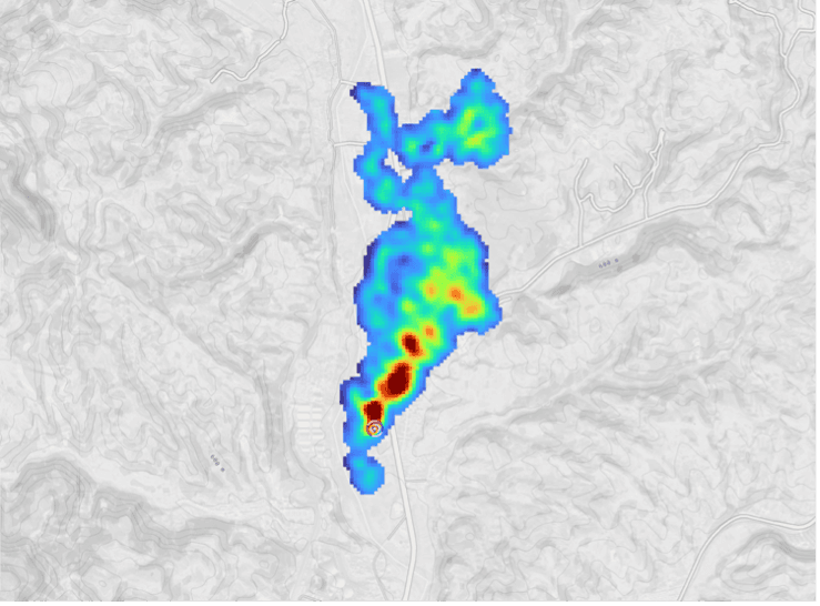
Coal: This plume was detected by Tanager-1 on May 9, 2026, in China. Carbon Mapper quantified the emissions rate as 9.0k kg CH4/hr.
Access the above images on our Data Portal:
- First image: View on our Data Portal
- Second image: View on our Data Portal
- Third image: View on our Data Portal
- Fourth image: View on our Data Portal
CO2
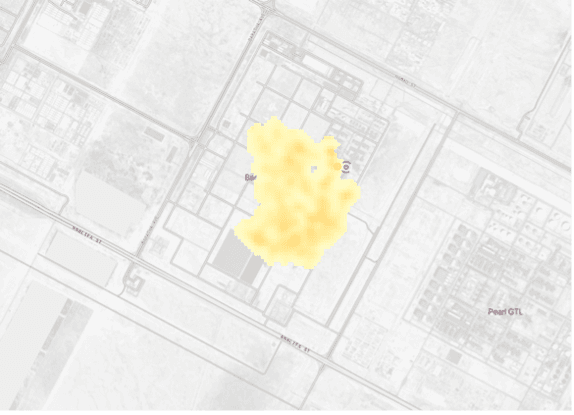
Oil and gas: This plume was detected by Tanager-1 on August 3, 2025, in Qatar. Carbon Mapper quantified the emissions rate as 1.1M kg CO2/hr.
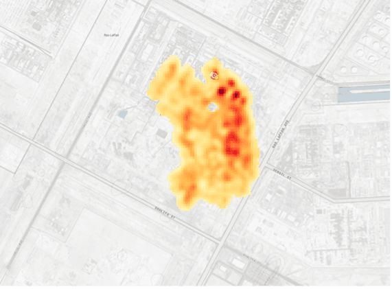
Electricity generation: This plume was detected by Tanager-1 on June 27, 2026, in Qatar. Carbon Mapper quantified the emissions rate as 3M kg CO2/hr.
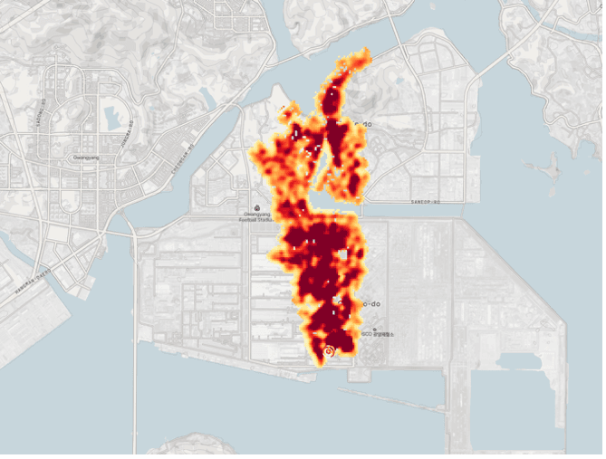
Manufacturing Industries: This plume was detected by Tanager-1 on July 11, 2026, in South Korea. Carbon Mapper quantified the emissions rate as 1.6M kg CO2/hr.
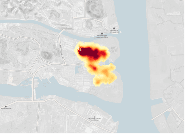
Other: This plume was detected by Tanager-1 on June 5, 2026, in Vietnam. Carbon Mapper quantified the emissions rate as 305k kg CO2/hr.
Access the above images on our Data Portal:
- First image: View on our Data Portal
- Second image: View on our Data Portal
- Third image: View on our Data Portal
- Fourth image: View on our Data Portal
What We've Accomplished – a Timeline of Tanager Milestones
August 16, 2024 – Tanager-1 Launches!
Tanager-1 launched into orbit from Vandenberg Space Force Base in California — the start of it all.
September 24, 2024 — First Light
First light images released by Planet.
October 10, 2024 – First Methane Detection
First methane detection released.
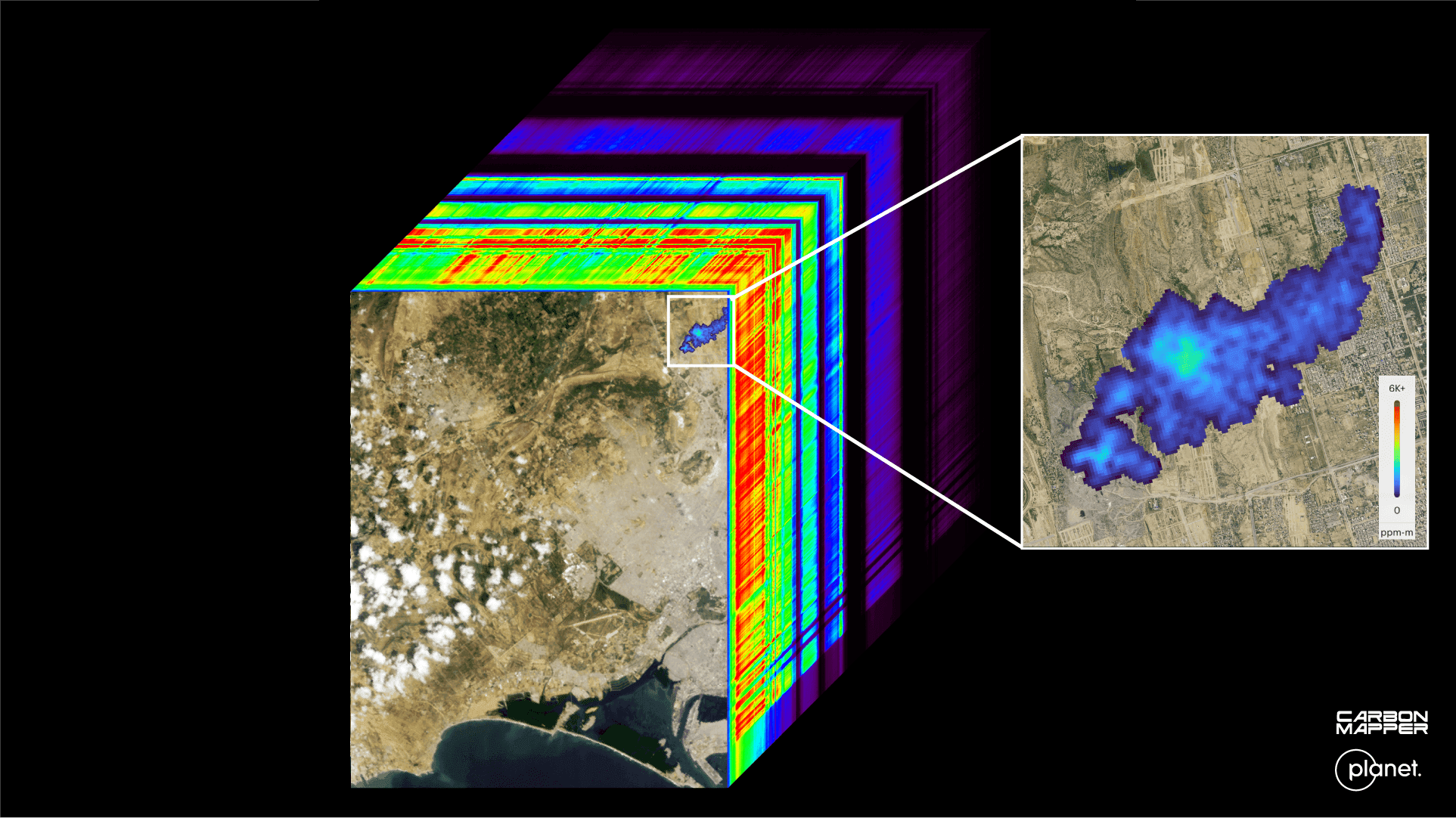
Left — the first methane plume detected in Tanager-1’s First Light hyperspectral data cube. Right — a detail of the methane plume detected at a landfill in Karachi, Pakistan on Sep. 19, 2024. Carbon Mapper’s preliminary estimate of the emission rate was 1,200 kg CH4 /h. Planet Basemap courtesy of Planet Labs. This first methane detection came within hours of the satellite overpass — days after the satellite’s instrument was activated and commissioning, and calibration was getting underway.
November 16, 2024 – First Methane Mitigation Released
Carbon Mapper released the first Tanager methane mitigation success — proof that satellite data can drive real emissions cuts.
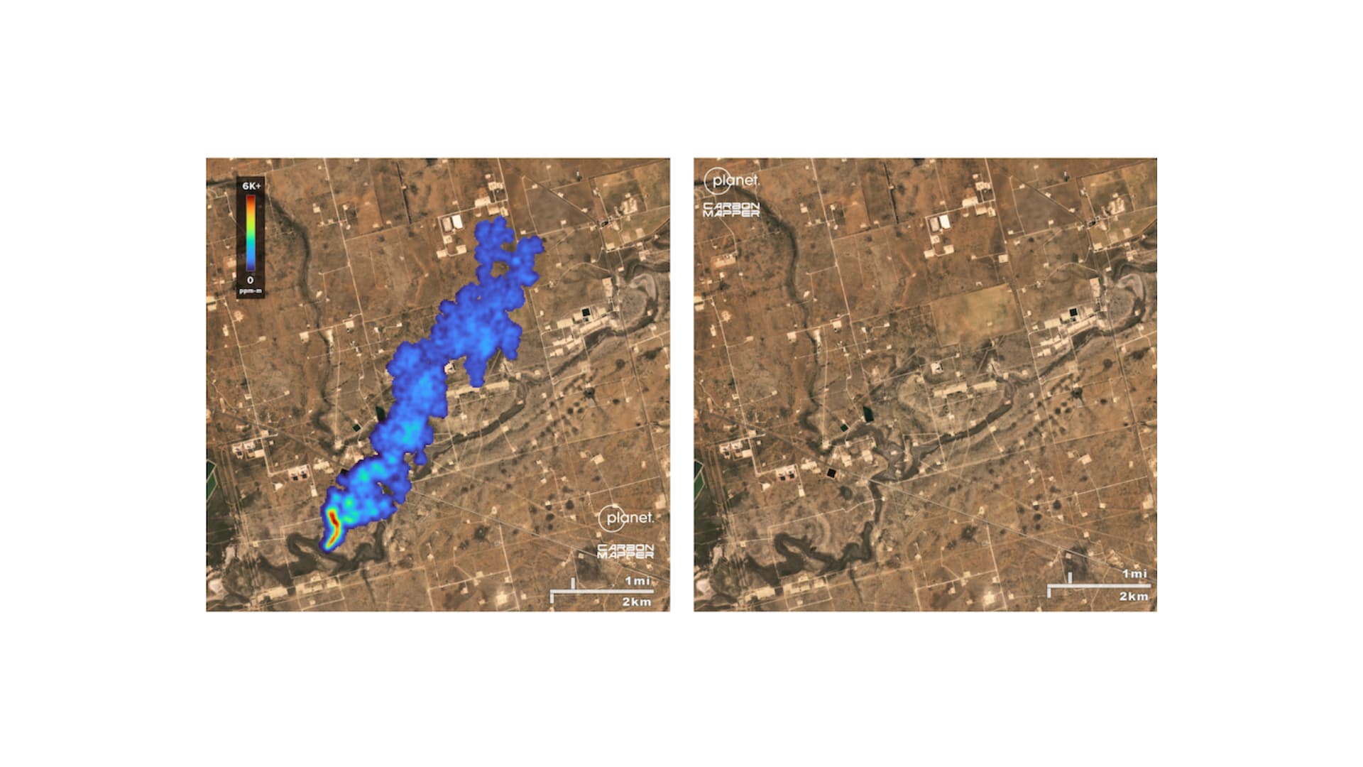
Left - a large methane plume from a leaking oil and gas pipeline was detected in the Texas Permian Basin by Tanager-1 on Oct. 9, 2024. After being shared with federal and state agencies, the leak was voluntarily fixed by the operator. Right - a subsequent Tanager observation on Oct. 24, 2024 detected no methane..
March 21, 2025 – California Becomes First State to Launch a Satellite Methane Program
California announced its Satellite Methane Program — partnering with Carbon Mapper to turn Tanager data into operator notifications and mitigation action across the state and beyond.
August 2025— Carbon Mapper Kicks off Mitigation Initiative
In 2025, Carbon Mapper began sending rapid methane-detection notifications to regulators and operators across select U.S. jurisdictions. In the initiative's first five months, we issued 60 notifications covering more than 50 unique sources — and our notifications and engagement helped confirm the mitigation of 10 sources, verified by state agencies, industry operators, and follow-up observations.
August 26, 2025 — New Tool Connects Super-Emitter Events to Health Risks
PSE Healthy Energy launched the Methane Risk Map, using Carbon Mapper’s Tanager data to show how super-emitter events affect communities across the U.S.
September 23, 2025 — Our First TAN-iversary!
We marked one year of Tanager-1 with a look back at the ways Carbon Mapper used the satellite to drive impact in its first year.
September 24, 2025 — Countries Start Building Satellite Data Into Methane Policy
Kazakhstan signed an MoU with the Global Methane Hub to build the country’s first National Methane Plan, using satellite technology including Tanager to detect and monitor major methane emissions from oil and gas and waste.

Kazakhstan signed an MoU with the Global Methane Hub to build the country’s first National Methane Plan. Photo courtesy of Global Methane Hub
November 4, 2025 — UCLA STOP Methane Project Brings New Context and Visibility to Methane Data
UCLA Emmet Institute launched the STOP Methane Project to produce a user-friendly ranking of super-polluting methane emissions across multiple sectors. They have used Carbon Mapper’s Tanager data to publish the top 10 most persistent oil and gas plumes in the United States, bringing more visibility to the mitigation opportunity posed by these sites. This was followed on by an April 2026 spotlight on 25 waste facilities in 18 countries responsible for the highest hourly emissions rates worldwide.
November 6, 2025 – A $100M Boost for Global Methane Mitigation
Bloomberg Philanthropies announced a $100M investment to launch “methane response basecamps” and expand the satellite constellation — accelerating global methane mitigation.
November 13, 2025 — California’s Satellite Program Delivers Results
CARB reported strong results from the first six months of the state’s CA Satellite Methane Project: using the Tanager-1 satellite and Carbon Mapper data, California identified and mitigated 10 oil and gas super-emitters.
November 15, 2025 – Brazil Steps Up to Tackle Methane Using Satellites
At COP30, host country Brazil announced an initiative to use satellite technology including Tanager to detect and mitigate methane from the country’s waste sector.
November 24, 2025 – Validating Tanager’s Capabilities
Carbon Mapper researchers published an article on the first 11 months of Tanager-1 data. The takeaway: the system is meeting — and in many cases surpassing — performance expectations.
February 27, 2026 – Highlighting the Biggest Mitigation Opportunities
Carbon Mapper analyzed Tanager observations to publish an analysis of the top persistent super-emitters worldwide — insights now used by organizations like the IEA in the global methane inventory.
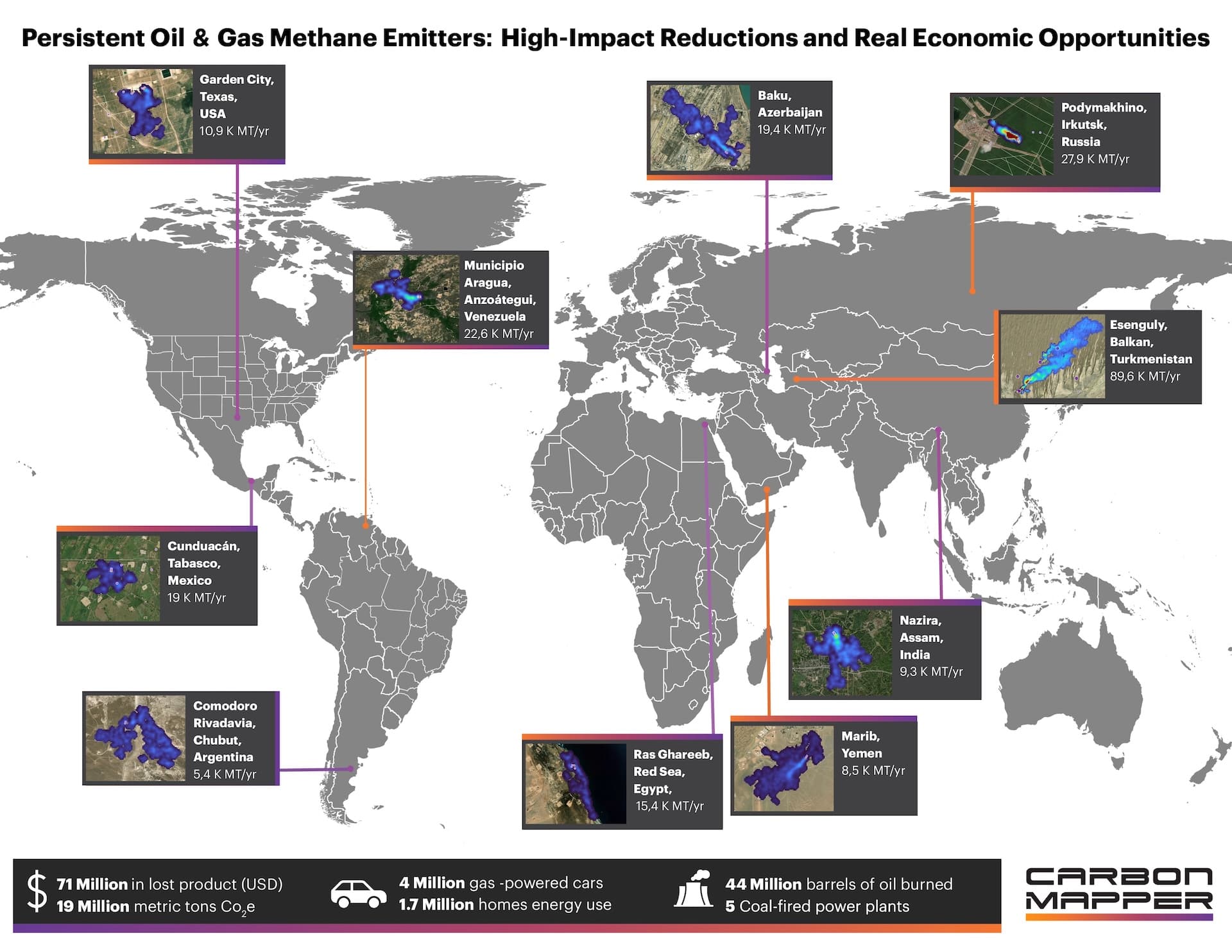
Carbon Mapper analyzed Tanager observations to publish an analysis of the top persistent oil and gas super-emitters worldwid.
March 3, 2026 — Carbon Mapper and OGCI Forge New Data to Action Pathways in the Oil and Gas Sector
Carbon Mapper and OGCI teamed up to put Tanager observations directly into the hands of global oil and gas operators who can act on them.
April 30, 2026 – Building out a Tiered Observing System
We announced plans to launch new Advanced Emissions Monitoring Imaging Spectrometer (AEMIS) technology, which Carbon Mapper will soon deploy on aircraft. Planet will integrate this same technology on a specialized satellite optimized to detect a wider range of atmospheric gases.
June 16, 2026 – Using Tanager to Detect Ammonia
Carbon Mapper researchers used Tanager to observe ammonia from space — the first time imaging spectroscopy technology has been used to do so.
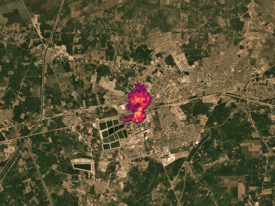
Ammonia emissions from an industrial source in Pakistan, detected using shortwave infrared radiance data from Planet’s Tanager-1. Basemap by Planet.
June 18, 2026 – A Major Data-to-Action Partnership With IMEO
Carbon Mapper announced a partnership with IMEO to integrate Tanager data into their MARS program, scaling up international oil and gas methane mitigation.
What's Next
Launching Tanager-1 was an important milestone, but opportunity still awaits. Thanks to the success of this satellite, Planet has committed to building and deploying three additional Tanager satellites and will integrate new imaging spectroscopy technology into one additional satellite. Growing the constellation will not only increase global coverage and sampling frequency, but will also yield new insights into critical, under-explored sectors and regions.
On the ground, we’re scaling this model. Our direct notification pipeline is expanding, putting more actionable data directly into the hands of operators and regulators who can reduce methane.
We are also deepening partnerships that turn data into policy and practice, working with regulators like CARB on California’s satellite-enabled mitigation program, industry coalitions like OGCI to drive oil and gas mitigation at scale, and with governments around the world as they build satellite data into national methane plans.
Join Us
Visit our data portal to learn more, subscribe to our newsletter, and follow us for regular news and updates.